Tuesday, February 9, 2021

¿Qué es un Deslinde?

 ¿Qué es?


¿Cómo se elabora?


¿Cuando lo utilizo?


Puede ver nuestro video sobre la explicación general de un Deslinde en la siguiente liga de nuestro canal de Youtube.


Saludos,

Ing. Ricardo Neyra

Perito Deslindador Certificado por el Ayuntamiento de Tijuana y Playas de Rosarito, B.C. (México).

neyra@urbanimex.com       www.urbanimex.com     www.drone-mappers.com


Monday, February 8, 2021

ALTA Survey in Mexico.

How are they developed by land surveyors in Mexico?


                              View Youtube video here.


The ALTA NSPS survey is a map developed by a certified land surveyor mainly used by lenders or title insurance companies. This map is a tool for the title company to provide insurance.


Regarding surveying work, you might ask if there is a difference as to how the ALTA survey is performed and delivered by Mexican surveyors?


The answer is no, though ALTA surveys are not common in Mexico, at Urbanimex we develop the ALTA survey map with the Standards set by the American Land Title Association (ALTA) and the National Society of Professional Surveyors (NSPS).


The new minimum standard detail requirements for the ALTA NSPS surveys will become effective this upcoming February 23rd of 2021. Download here.


All of the 32 States of Mexico regulate the practice of surveying within their jurisdictions, many of them very similar. At Urbanimex we perform the ALTA survey according to the corresponding jurisdiction but also in accordance with the standards set by ALTA & NSPS, as mentioned in 3. B. the more stringent standard of practice must apply for the ALTA NSPS survey.


At Urbanimex we have developed numerous ALTA Surveys for Mexican and abroad clients. We provide our ALTA Surveys information of the subject property according to ground data and public records.


If any type of problems or differentials is shown in the ALTA Survey, the title insurance company or lender will take an exception to those on the title policy. Problems or differentials regarding the work of the Boundary Survey of the ALTA survey could be overlaps, encroachments, gaps, easements, rights of way, on-site, or on documents.


Besides the information of a Boundary Survey in the ALTA, this map may also show improvements, underground utilities, contour lines, elevations, building setbacks, just to mention a few. Any additional information specified in Table A of the Standard Requirements can be provided upon request by the client.


If you require an ALTA NSPS survey in any part of Mexico, please feel free to contact us for any consultation. We are located in the City of Tijuana, Mexico.


Best regards,


Ricardo Neyra, CE PLS 

neyra@urbanimex.com www.urbanimex.com www.drone-mappers.com

Tuesday, March 5, 2019

PLANOS CATASTRALES, ¿qué son y para qué se utilizan?

Todo Municipio tiene su Dirección de Catastro cuya finalidad es tener un inventario o padrón de todos los inmuebles que se encuentren dentro de su límite municipal.

Cada inmueble tiene su expediente referenciado con una clave catastral única, en este expediente existe información escrita y gráfica, ésta última siendo a través de Planos Catastrales.

Alguna vez ha escuchado este término, ya sea por alguna transacción inmobiliaria (compra-venta, escrituración, prescripción, etc.) o como requisito para solicitar una licencia de construcción.

Para los Municipios de Tijuana y Playas de Rosarito de Baja California, existen 4 tipos de Planos Catastrales, a continuación se describen.

1.  ACTA DE DESLINDE. Requiere medición topográfica previa en sitio para análisis de linderos oficiales del inmueble de interés y colindantes, así como representar en plano si existe alguna afectación, invasión o sobreposición con algún colidante, en algunos casos existen errores en la descripción escrita del inmueble (escritura) ya sea en medidas y/o superficie y/o colindancias, esta también se representa en este tipo de plano.

Uso: donación, subdivisión, fusión, relotificación, verificación de lindero, traslación de dominio, licencia de construcción. Nota: este trabajo debe ser desarollado por un perito autorizado y aplica para inmuebles con superficie menor de 5,000.00 m2.


2.   ACTA DE LEVANTAMIENTO. Requiere medición topográfica previa en sitio, en este plano se representa las medidas y colindancias actuales del inmueble, omitiendo en plano su situación con algún colindante, sólo se hace referencia en nota si existe mayor o menor superficie de la contenida en la descripción escrita (en caso de existir).

Uso: alta en padrón catastral, prescripción judicial, traslación de dominio. Nota: este trabajo debe ser desarollado por un perito autorizado y aplica para inmuebles con superficie menor de 5,000.00m2.

3.   CERTIFICACIÓN DE POLIGONO. El trabajo y uso es igual al del plano tipo Acta de Deslinde, sólo que aplica para inmuebles con superficie mayor de 5,000.00m2. Nota: este trabajo debe ser desarollado por un perito autorizado.

4.  CERTIFICACION DE DATOS CARTOGRAFICOS. Este plano es para inmuebles que se encuentren bajo regimen de propiedad en condominio, de existir en expediente planos son meramente copias certificadas de planos arquitectónicos en conjunto con una descripción escrita de área(s) privativa (medias, colindancias y superficies).

Uso: traslación de dominio. Nota: este trabajo requiere ser realizado a través de perito auturizado sólo en caso de no existir planos en expediente.


Esperando esta información le sea de utilidad, en caso de tener alguna duda o comentario, con gusto le respondemos.

Le informamos que formamos parte del padrón de peritos autorizados para este tipo de trabajos ante las siguientes dependencias Municipales:
  • Dirección de Catastro del Ayuntamiento de Tijuana, B.C.
  • Dirección de Catastro del Ayuntamiento de Playas de Rosarito, B.C.
Saludos,

Ing. Ricardo Neyra

neyra@urbanimex.com

Monday, March 4, 2019

ALTA NSPS Land Title Survey in Mexico.


When purchasing a property in Mexico, it's better to play it safe and have a detailed ALTA NSPS land title survey for your title insurance.

It is not common for mexican citizens to acquire title insurance in a real estate transaction, a vast majority of mexican attorneys and real estate agents don't believe you need this product/protection, they might not even mention this option.

In Mexico the transfer of ownership rights is reliant upon Public Notary's, their acknowledgment and certification procedure provides judicial certainty to the authenticity of the process.

The Notarial system in Mexico is trustworthy, but never lose sight that the system is reliant on the performance of various people such as property recorders, municipal employees, surveyors, agents and others.

Mistakes might happen and this is human. Unfortunately their is also forgery, sometimes fabricated documents that affect property ownership are filed with public records.

At Urbanimex we are a team of professional land surveyors, offering high quality work on ALTA NSPS land title surveys for any part of Mexico.

Our surveying team has over 15 years experience, and we are convinced that surveying firms are the best option to detect any fabricated description, fabricated surveys, description errors, unknown easements, boundary lines.


Our advice is to play it safe in Mexico and get covered by an owner's policy of title insurance and also make sure your ALTA NSPS land title survey meets with the Minimun Standard Detail Requirements: https://www.nsps.us.com/page/ALTANSPSStandards

Feel free to contact us if you have any questions or comments.

Best regards,

Ricardo Neyra
neyra@urbanimex.com


www.drone-mappers.com             www.urbanimex.com


ALTA Survey Mexico
ALTA NSPS Survey Mexico
Title Insurance Mexico
Mexico Title Insurance


Thursday, September 22, 2016

Why is an ALTA Survey needed?


Many parties to a real estate transaction rely on the ALTA/NSPS Land Title Survey for the following:

  • As part of due diligence when property is being transferred or refinanced.

  • To locate both record and non‐record matters that aect the property which can be critical for evaluating whether or not to proceed with the acquisition.

  • Showing interested parties the potential risks and benefits from property ownership recognizing issues such as:  boundary line conflicts,  encroachments, easements, contiguity between parcels, access to highways, zoning issues, and other potential losses and claims against the land  that may arise after  purchase.

  • To satisfy the Title Insurer’s requirements for the issuance of ALTA Title Insurance coverage for survey risk such as encroachments, boundary disputes, etc.

  • Removing survey exceptions from a title commitment. 

  • The dates on the ALTA/NSPS survey provide verification of actual matters as they existed before the survey. This protects sellers of property from claims that may be brought by the lender or buyer after conveyance. 

If you have any questions, please feel free to contact us with any of our partner companies www.urbanimex.com or www.drone-mappers.com 

Best regards,

Ricardo Neyra
neyra@urbanimex.com

Wednesday, September 11, 2013

...continuación PLANOS CATASTRALES

El día 03 de Enero de 2013 compartimos un tema llamado PLANOS CATASTRALES en específico para los Municipio de Tijuana y Playas de Rosarito, B.C.

Aquí les presentamos un resumen gráfico.

Para mayor información visitar la página http://www.urbanimex.com/


Saludos,

Ing. Ricardo Neyra
Consultores Urbanos e Inmobiliarios de México, S.C.

Tuesday, August 6, 2013

ALTA Survey in Mexico.

ALTA surveys are usually requested by title companies, attorneys and lending institutions when they are involved with real estate transactions involving in most cases highly valuable commercial or industrial or residential properties.

The American Land Title Association (ALTA) have specific needs, unique to title insurance matters, when asked to insure title to land without exception as to the many matters which might be discoverable from survey and inspection, and which are not evidenced by the public records.  

ALTA surveys developed in Mexico by www.urbanimex.com are no different than those performed in the United States, they are high quality survey performed in accordance with the requirements and standards as established by the American Land Title Asociation (ALTA) y a la National Society of Professional Surveyors (NSPS).


ALTA Survey  (Palmilla, Los Cabos)

Currently, we adhere ALTA surveys to the newest version of standards (Effective February 23, 2016).

There are two parts to develop an ALTA survey; the first part is performed on site collecting the field data and consulting with public records and agencies with infrastructure at the site, the second part is drafting the survey and putting everything together so we can complete the final plat and our report.

Time & cost for ALTA surveys depend on specific conditions of the site, please contact us for a free estimate at:

https://www.facebook.com/ALTASurveys/

www.altasurveys-mexico.com

www.drone-mappers.com

www.urbanimex.com

Best regards,

Ricardo Neyra


Thursday, January 3, 2013

PLANOS CATASTRALES


Todo Municipio tiene su Dirección de Catastro cuya finalidad es tener un inventario o padrón de todos los inmuebles que se encuentren dentro de su límite municipal. 

Cada inmueble tiene su expediente referenciado con una clave catastral única, en este expediente existe información escrita y gráfica, ésta última siendo a través de Planos Catastrales.

Alguna vez ha escuchado este término, ya sea por alguna transacción inmobiliaria (compra-venta, escrituración, prescripción, etc.) o como requisito para solicitar una licencia de construcción.

Para los Municipios de Tijuana y Playas de Rosarito existen 4 tipos de Planos Catastrales, a continuación se describen. 

1.  ACTA DE DESLINDE. Requiere medición topográfica previa en sitio para análisis de linderos oficiales del inmueble de interés y colindantes, así como representar en plano si existe alguna afectación, invasión o sobreposición con algún colidante, en algunos casos existen errores en la descripción escrita del inmueble (escritura) ya sea en medidas y/o superficie y/o colindancias, esta también se representa en este tipo de plano. Uso: donación, subdivisión, fusión, relotificación, verificación de lindero, traslación de dominio, licencia de construcción. Nota: este trabajo debe ser desarollado por un perito autorizado y aplica para inmuebles con superficie menor de 5,000.00 m2.


2.   ACTA DE LEVANTAMIENTO. Requiere medición topográfica previa en sitio, en este plano se representa las medidas y colindancias actuales del inmueble, omitiendo en plano su situación con algún colindante, sólo se hace referencia en nota si existe mayor o menor superficie de la contenida en la descripción escrita (en caso de existir). Uso: alta en padrón, prescripción judicial, traslación de dominio. Nota: este trabajo debe ser desarollado por un perito autorizado y aplica para inmuebles con superficie menor de 5,000.00m2.


3.   CERTIFICACIÓN DE POLIGONO. El trabajo y uso es igual al del plano tipo Acta de Deslinde, sólo que aplica para inmuebles con superficie mayor de 5,000.00m2. Nota: este trabajo debe ser desarollado por un perito autorizado.


4.  CERTIFICACION DE DATOS CARTOGRAFICOS. Este plano es para inmuebles que se encuentren bajo regimen de propiedad en condominio, de existir en expediente planos son meramente copias certificadas de planos arquitectónicos en conjunto con una descripción escrita de área(s) privativa (medias, colindancias y superficies). Uso: traslación de dominio. Nota: este trabajo requiere ser realizado a través de perito auturizado sólo en caso de no existir planos en expediente. 


Esperando esta información le sea de utilidad, en caso de tener alguna duda o comentario, con gusto le respondemos.

Le informamos que formamos parte del padrón de peritos autorizados para este tipo de trabajos ante las siguientes dependencias: 

  • Dirección de Catastro del Ayuntamiento de Tijuana, B.C.
  • Dirección de Catastro del Ayuntamiento de Playas de Rosarito, B.C.
  • Poder Judicial del Estado de Baja California, Consejo de la Judicatura del Estado.

Saludos,

Ing. Ricardo Neyra
Consultores Urbanos e Inmobiliarios de México, S.C.

Saturday, December 3, 2011

PROPERTY DEVELOPMENT DUE DILIGENCE FOR FUTURE LAND DEVELOPMENTS.

REDUCE THE RISK OF YOUR INVESTMENT.

Every project is born with an idea and subsequently continues its process when the market study shows attractive facts for the investor(s), but there are other very important elements before closing or acquiring a property where the development is to be built that are not reflected or shown in the market study, like knowing the physical, technical and legal conditions under which the site and the project will be ruled. These conditions will aid the decision in knowing if the site is feasible and the estimated cost to carry out the development from A to Z, from its original idea to its construction. It is why the importance of developing a Property Development Due Diligence study for any Land Development.

In our personal professional practice the following Property Development Due Diligence diagram or checklist has aided and given great results for land development projects, in all cases there is the need of adding or removing some work, this is only an example.


The checklist/diagram for Property Development Due Diligence is useful as a guide to help develop and present our client a report with all the important aspects that will play a significant role in deciding if the site selected for the project is the best option. In some cases the result will be selecting a different site or more drastically modifying several aspects of the original land development idea and adapting them to the selected site. These are very important decisions before performing a larger investment (time and money).

The purpose of the Property Development Due Diligence is to increase the possibilities of success of the development and of your investment. Know the more you can of the site before, during and after your investment.

It is very important knowing all details of the client’s idea for the land development in order to be capable of developing a build to suit Property Development Due Diligence.

The previous Property Development Due Diligence diagram or checklist changes according to the requirements of each project and/or the demands of the client. There are 7 lines of action or analysis that area required to be done in order to develop a complete Property Development Due Diligence report: Basic Site Information; Site Norms; Actual Infrastructure at the Site and surroundings; Physical Site Information; Concept Plans for Development; Development Permitting Information; Site Financial Information.

Basic Site Information. The first step is to perform a physical visit to the site to become acquainted with the site, the location and its surroundings, subsequently knowing its geographic location with the support of maps containing the size of the site, boundaries and other information.

Site Norms. Subsequently with the geographic reference of the site it is possible to determine under what jurisdiction the site in located and what laws, regulations and development programs are needed to be analyzed to know all future conditions, restrictions and other elements that the land development project will be held under. Example: the conditions, restrictions for a urban development site (residential, commercial or industrial) will be very different from a development site for a self sufficient ocean front community outside the urban scene of a city.
Actual Infrastructure at the Site and Surroundings. This is a very important analysis within the Property Development Due Diligence, since the results will let know the existence of infrastructure in the area and if the actual infrastructure has the capacity of providing service for the development.
If there were no infrastructure in the area and/or is not within the future infrastructure expansion plans, it is necessary to propose alternative infrastructure solutions. The information obtained from this line of action or analysis, will help develop infrastructure design guidelines for the development (electricity, water, sanitary, roads, etc.).
Physical Site Information. Part of the Property Development Due Diligence is to create a Concept Plan of the Development (1st visual image of the Project), but in order to be developed it is necessary to obtain physical information of the site to create a Concept Plan that is related to the actual conditions of the site, the two main elements are the topography and geotechnical studies. Both studies are linked to develop a Concept Plan, the topography will show the actual form of the surface of the site, steepness of slopes, flooding areas and storm water natural flow; the geotechnical study will reveal subsurface earth material properties/conditions as well as their physical and mechanical properties in order to obtain recommendations and guidelines for designing earthworks, retaining walls, etc., all relevant to possible natural hazards such as earthquakes, landslides, etc.
Besides being of great use during the Property Development Due Diligence, the topography and geotechnical studies are also utilized during future designing phases of the development.
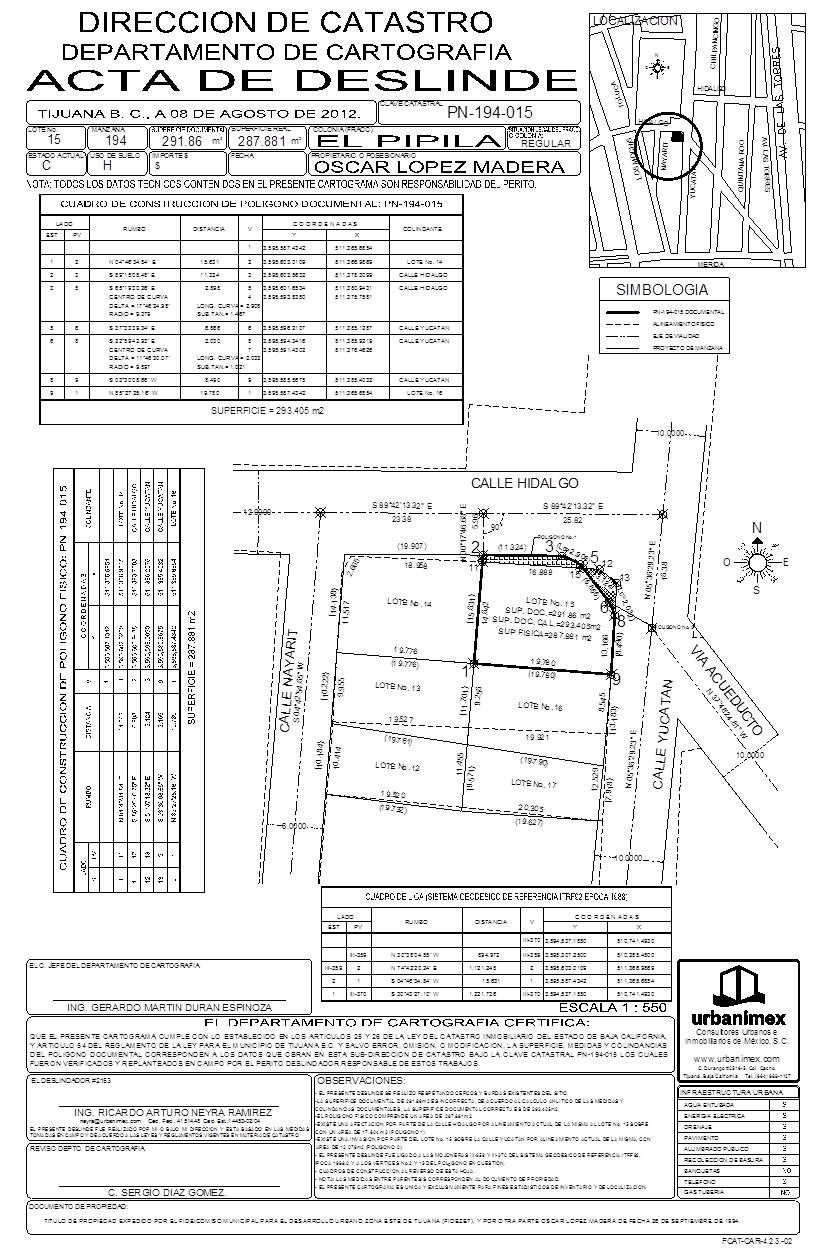
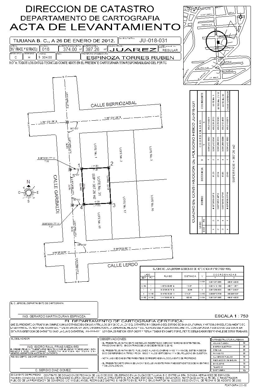
Concept Plan for the Development. Utilizing the infrastructure design guidelines, the physical characteristics of the surface and subsurface of the site, combined with the clients idea and the project developer experience and design contribution, gives enough elements to elaborate a first Concept Plan of the Development within which a visual representation of roads, setbacks, lots, non buildable areas and possible building footprints are illustrated.
Nevertheless, it is not only about obtaining a visual representation of the development, but very importantly it becomes the source to obtain real data of the development like the accurate area of sellable land, accurate area of non buildable zone(s), accurate area assigned for roads, infrastructure location and connection points. All this information can be translated to money and obtain a preliminary estimate of the real cost for the urbanization/construction of the development.
 Example of a Concept Plan. 

Development Permitting Information. Knowing what governmental authorities as well as what studies and projects to be revised, are all crucial facts so the investor does not waste time and money in unnecessary work. 

Site Financial Information. This information is the most important for the decision makers of the development, knowing what is the preliminary total cost of the studies, projects, government fees and construction of the Project, all from start to finish. This information can only be obtained once the previous six lines of action or analysis have been done. Developing the Concept Plan is the main source for obtaining real numbers for the preliminary total cost.


There are government fees that many investors are not aware of or don’t have the data at reach before starting a project or closing a property deal where the development will be built. Just to mention one example, if the project is an Industrial Park, a residential subdivision (“Fraccionamiento”) or any other type of development, in Baja California, Mexico, according to law the municipal authority applies a 2.775% fee of the total cost of the urbanization of the development.

There are other municipal, state and federal government fees that require attention prior to making final decisions that can affect the development process.

I highly recommend that any person involved in the land development market, even if your next or current Project is small or large, that a complete Property Development Due Diligence be considered to aid your investment decision. Know the most you can before closing. 

Remember, the most profitable investors don’t gamble, they go with facts.

Regards,
Ricardo Neyra

Monday, August 22, 2011

Tijuana: "Pueblo Bicicletero"?

Tijuana como "Pueblo Bicicletero"?, bueno, la realidad es obvia, Tijuana es la ciudad dominada por el automóvil y de "Pueblo Bicicletero" no tiene nada y lo digo literalmente NO TIENE NADA.

La Zona del Río, un lugar donde el precio por m2  del suelo es de los más altos de la Ciudad, hoy tiene destinado un 35% de superficie a vialidades para que transiten los vehículos (y algunos peatones). Y a cambio de que?, mucho tráfico, perdida de tiempo, estrés y motores contaminando, pero si hay actividad económica y "algo" de interacción social.

Los que conocen la Zona del Río, saben que con cualquiera de los siguientes eventos o combinados hacen que se paralice la zona:
  • La espera para el cruce vehícular a San Ysidro.
  • Concierto en las "Tijeras"
  • Desfile Coca-Cola
  • Protesta de transportistas.
  • Victoria de un partido de la selección mexicana de fútbol.
  • Etc.


Es probable que quienes planearon y/o aprobaron el desarrollo de la Zona del Río de Tijuana lo hicieron pensando como prioridad en el automóvil, de hecho todavía se sigue pleanado y desarrollando bajo este patrón por toda la Ciudad, el recién ignaurado Distribuidor Vial El Florido (2011) no tiene manera de cruzarse a pie o en otro medio de transporte de manera segura que no sea el automóvil (no le quito su mérito de conectar a Playas de Tijuana con el Refugio.....pero sólo en vehículo).

Poco a poco esta dependencia total del automóvil en Tijuana tenderá a disminuir de manera natural por uso de razón de ciudadanos y autoridades.

Existen varios estudios y proyectos para diversas zonas de la Ciudad de Tijuana  desarrollados por el Instituto Metropolitano de Planeación (IMPLAN) con el objetivo de mejorar o resolver temas como el transporte público, ciclovías, parques, etc., pero lamentablemente muchos se quedan sólo en eso en un proyecto y no se llevan a cabo.

Las razones por las que no se llevan a cabo no se si sean por cuestiones políticas, falta de interés por parte de autoridades, dificultad en obtener recursos públicos, nose, el caso es que no se llevan a cabo.

Pero hay buenas noticias!, ya se logra ver una pequeña luz al final del tunel!, Esta despertando desde hace algunos años un sector de la población y este es se esta haciendo notar a través de diversos grupos de ciclistas, quizá los han visto durante las tardes "pedalear" o "rodar" por vialidades de la Ciudad. 

Estos grupos además de hacer ejercicio, crear un ambiente sano de convivencia entre otros beneficios, tienen un objetivo clave, hacer llegar al resto de la ciudadanía y al gobierno que las vialidades de la Ciudad también les pertenece y quieren utilizarlas en su vida diaria (al igual o más que el automóvil).

Y el tema no es que ellos quieren utilizar las calles sólo para pasearse o hacer ejercicio, va más allá, con su acción nos están diciendo que el uso de la bicicleta es otro medio de transporte urbano, que podemos trasladarnos de "A" a "B" sin necesidad del automóvil. Un medio de transporte que ejercita, es barato adquirirlo al igual que su mantenimiento y lo mejor de todo es que no contamina.

En Tijuana, menos de 1% de su población utiliza la bicicleta, y no es de extrañarse ya que la Ciudad no tiene las condiciones de infraestructura para bicicletas, en algunas ciudades de Europa entre el 40%-60% utiliza la bicicleta.

Además vivimos en una Ciudad y sociedad en la que tu medio de transporte es considerado un reflejo de tu status social, si tienes un automóvil de reciente modelo eres una persona exitosa, si tu medio de transporte es en taxi, camión o calafia eres una persona poco exitosa.....y que si te transportas en bicicleta? es seguro que te vean como una persona con éxito casi nulo.

De acuerdo al Arq. Rodolfo Argote de IMPLAN en su presentación en el Foro de Movilidad Urbana celebrado los días 5 y 6 de Agosto en Tijuana, existen 3 elementos para que la ciudad de Tijuana pueda dar ese cambio hacia una Ciudad en la que cuente con infraestructura para ciclovías:

  1. Disposición de los 3 niveles de gobierno.
  2. Grupos ciudadanos. (Ya existen). Estos grupos tendrán que ser los responsables de presionar constantemente a los 3 niveles de gobierno.
  3. Que el IMPLAN incluya en sus Planes de Desarrollo infraestructura de ciclovías. Recordemos que los Planes de Desarrollo son instrumentos de planeación que se vuelven ley. Actualmente el IMPLAN tiene 9 rutas aptas para ciclovías, donde 7 están en propuesta y 2 están en Proyecto Ejecutivo (Playas de Tijuana y Zona Río Tijuana-Bulevar Agua Caliente).
Una ventaja de los proyectos de ciclovías es que la inversión de su infraestructura es más baja en comparación con  invertir infraestructura para automóviles. Además que genera un mayor número de empleos, vialidades para automóviles en su mayoría se realizan con maquinaria pesada y pavimentadoras, para ciclovías son trabajos con espacios más reducidos donde la mano de obra directa es necesaria.

Se esta avanzando en el tema de las ciclovías, pero lo mejor es que cada día es más grande la comunidad que estoy seguro estará empujando para lograr que Tijuana se convierta en una Ciclociudad. La verdad no me importa si algún día (largo plazo) le dicen a mi Tijuana "Pueblo Bicicletero", al contrario será un orgullo.

Saludos,

Ricardo Neyra


Si leíste lo anterior, recomiendo te tomes 15 minutos para tener un panorama más amplio con estos 2 videos relacionados con el tema (los videos son de la página http://www.ciclociudades.mx/)  Les recomiendo también visitar las páginas http://www.itdp.mx/  y http://www.pueblobicicletero.org/